
Southern Africa spans an immense 6.8 million square kilometer’s, a vast region where the land meets two great oceans — the Indian Ocean to the east and the Atlantic Ocean to the west.

Southern Africa is generally understood to include Angola, Botswana, the Comoros, Eswatini (Swaziland), Lesotho, Madagascar, Malawi, Mauritius, Mozambique, Namibia, South Africa, Zambia, and Zimbabwe. In cultural geography, however, Madagascar is often excluded due to its unique language and distinct cultural heritage.
From a physical geography perspective, the sub-region is defined more narrowly as the part of Africa lying south of the Cunene and Zambezi Rivers — encompassing Botswana, Eswatini, Lesotho, Namibia, South Africa, Zimbabwe, and the southern portion of Mozambique below the Zambezi River. 
This narrower definition of Southern Africa is most often used in South Africa within the natural sciences and in specialist guidebooks such as Roberts’ Birds of Southern Africa, the Southern African Bird Atlas Project, and Mammals of the Southern African Sub-Region. It is rarely applied in political, economic, or human geography, as it divides Mozambique into two distinct parts.
The terrain of Southern Africa is remarkably varied, ranging from dense forests and open grasslands to arid deserts. The landscape shifts from low-lying coastal plains to rugged mountain ranges. The region is exceptionally rich in natural resources, boasting the world’s largest reserves of platinum and the platinum group elements, as well as significant deposits of chromium, vanadium, cobalt, uranium, gold, copper, titanium, iron, manganese, silver, beryllium, and diamonds.
Southern Africa stands apart from other Sub-Saharan African regions largely due to its vast mineral wealth, which includes copper, diamonds, gold, zinc, chromium, platinum, manganese, iron ore, and coal. Most countries in the region are expansive in geographic size, with the exceptions of three smaller landlocked states: Lesotho, Eswatini (Swaziland), and Malawi. The larger nations — South Africa, Botswana, Mozambique, Zimbabwe, Zambia, Namibia, and Angola — all boast extensive mineral deposits that play a central role in their economies.
These widespread mineral resources make this one of the wealthiest regions of Africa with the greatest potential for economic growth. A chain of mineral resources in Southern Africa stretches from the rich oil fields in northwest Angola, east through the central diamond-mining region in Huambo Province, and into the Copper Belt region of Zambia and Congo. 
A region of rich mineral deposits continues to the south called the Great Dyke in central Zimbabwe, through the Bushveld basin into South Africa. This extends southwest through the Witwatersrand and Northern Cape of South Africa toward the southern coast. Mining activity exists across the eastern region. Diamond mining is found in parts of Botswana and along the Namibian coast. Coal can also be found in central Mozambique, Zimbabwe and northeast South Africa.
The climate of the region is broadly divided into subtropical and temperate regions in the north and south respectively, but also includes humid Sub-Tropical, a Mediterranean climate, highland subtropical, oceanic, desert and semi-arid regions. 
Except for lower regions of Zambia and interior regions of Namibia and Botswana, the region rarely suffers from extreme heat. In addition to that, the winter presents mostly mild and dry, except in the southwest. Cool southeasterly winds and high humidity bring cool conditions in the winter. The Namib Desert is the driest area in the region.
Altitude plays an outsize role in moderating the temperatures of the South African Highveld, Lesotho and much of Zambia and Zimbabwe. The prairie region of central and northeast South Africa, Zimbabwe and parts of Zambia is known are known as the veldt, divided into the Bushveld and Highveld regions. There are high temperatures and low rainfall inside the Zambezi and Limpopo river valleys, probably due to the lower altitude.
The Western Cape has a Mediterranean vegetation and climate, including the unique fynbos, grading eastward into an oceanic climate along the Garden Route to Gqeberha (Port Elizabeth) and East London. The Namib and Kalahari deserts form are arid lands in the center-west separating the highlands, woodlands, croplands and pastures of wetter and higher East from the Atlantic Ocean. 
In addition, the Drakensberg and Eastern Highlands separate the highland areas and coastal plains centered on Mozambique in the north and KwaZulu-Natal to the south, the latter of which are often prone to flooding every few years.
Der Nama-Führer Hendrik Witbooi, um 1900. Nach dem Tod von Witbooi in Oktober 1905 führten Jacob Marengo, Cornelius Frederiks und Abraham Morris den Guerillakampf der Nama gegen die deutsche Schutztruppe fort. Samuel Maharero (1856-1923), son of Maharero (1820-1890)
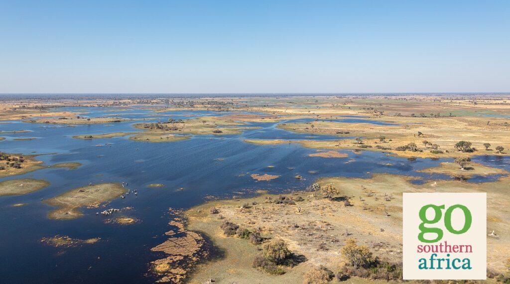
Namibia is primarily a large desert and semi-desert plateau. Quivertree Forest, Bushveld. In the east the river systems of the Zambezi and Limpopo basin form natural barriers and sea-lanes between Mozambique, South Africa and Zimbabwe.
Limpopo is the northernmost province of South Africa. It is named after the Limpopo River, which forms the province’s western and northern borders. The capital and largest city in the province is Polokwane, while the provincial legislature is situated in Lebowakgomo.
The province is made up of three former homelands of Lebowa, Gazankulu and Venda. Limpopo is made up of three main ethnic groups: the Pedi, the Tsonga and the Venda.
Across most of southern Africa, apart from the Western Cape in South Africa, the major rainfall season is during the southern hemisphere summer (December to February). In the Western Cape the rainfall maximum is in June through to August.
There are a number of important rainfall producing weather systems in southern Africa. These include, tropical-extra tropical cloud bands, tropical lows and tropical cyclones, cut-off lows and mesoscale convective systems. Winter midlatitude storms account for the June-August rainfall maximum in the Western Cape.
Year to year variability in rainfall, including droughts, are associated with changes in global and regional sea surface temperatures. These include the El Nino Southern Oscillation, the Subtropical Indian Ocean Dipole and changes in the Benguela Current region in the southeast Atlantic. Future climate projections suggest that much of southern Africa will get hotter and drier in response to global climate change.